Groundwater Geology
ECI professionals bring over 25 years of experience to solving complex challenges involving water supply, protection, management and planning. The challenges imposed by competing demands between growing urban populations and agricultural needs, further impacted by the complications from of climate changes and our improved understanding of “emerging” groundwater contaminants, creates the necessity and opportunity for creative solutions to water supply development and management. In California and other drought-impacted regions of the western United States, a new aggressive statutory and regulatory framework for water-supply sustainability requires a multi-disciplinary approach to solving these water resource challenges, via the incorporation of important elements such as the development of improved conceptual models for groundwater basins, low impact land development (LID) and conservation measures, storm runoff assessment and capture, and wastewater recycling
- Operational safe yield assessments for individual aquifers and/or entire groundwater basins, in support of both groundwater sustainability and adjudication matters
- Numerical and analytical modeling simulations for groundwater recharge, pumping well extractions, wellhead protection in areas of contamination, and long-term drought planning scenarios
- Surface hydrological assessments, including storm-frequency/magnitude estimates for groundwater recharge and conjunctive use systems
- Design, installation and development of maximum-efficiency groundwater production wells and networks
- Performance optimization and rehabilitation engineering for older inefficient production wells, including pump and packer design and installation
- Water-supply planning documents, including residential and commercial development demand studies (SB 221 and SB610), regional water management plans (UWMPs and IRWMPs), and Groundwater Sustainability Plans (GSPs)
- Wetlands and streambed protection and alteration assessments compliant with Federal CleanWater Act Section 404 regulations and permitting.
- Watershed erosion and sediment/pollutant loading studies for water quality protection in reservoirs, streams, lakes and coastal zones, compliant with CEQA/NEPA, NPDES and Federal CleanWater Act Section 303
- Preparation of Stormwater Pollution Prevention Plans (SWPPPs) and engineering design of Best Available Technologies for variety of earthwork projects
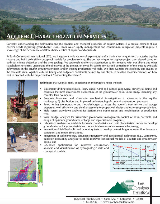
Techniques that we may apply depending on the project’s needs include:
- Exploratory drilling (direct-push, rotary and/or CPT) and surface geophysical surveys to define and constrain the three-dimensional architecture of the groundwater basin under study, including any complex fault boundaries,
- Borehole flowmeter and downhole geophysical investigations to characterize the aquifer stratigraphy, Q distribution, and improved understanding of contaminant transport pathways,
- Pump testing (constant-rate and step-discharge) to assess the aquifer’s transmissive and storage properties, well efficiency, and yield assessment for proper well design and water-supply prediction,
- Yield versus drawdown analyses for performance optimization and rehabilitation of production wells
- Water budget analyses for sustainable groundwater management, control of basin overdraft, and design of optimum groundwater recharge and replenishment programs,
- Wetlands and streambed protection and alteration assessments compliant with Federal CleanWater Act Section 404 regulations and permitting.
- Laboratory analyses to establish hydraulic conductivity and soil characteristic curves to develop groundwater recharge constraints and conceptual models of vadose-zone hydrology,
- Integration of field hydraulic and laboratory tests to develop defensible groundwater flow boundary conditions and model simulations,
- Integration of sedimentology, sequence stratigraphy and geostatistical techniques (e.g., variograms, transition-probability analyses) to build improved conceptual models of aquifers and groundwater basins
- GIS-based applications for improved construction, analysis and visualization of hydrogeologic data and conceptual models